Tornadoes have been spotted in parts of South Florida as Hurricane Milton draws closer, prompting authorities to urge residents to safety.
As of Wednesday morning, October 9, 2024, multiple tornadoes were reported across South Florida. The National Weather Service Miami-South Florida (NWS Miami) office issued urgent warnings as more severe weather, fueled by the approach of Hurricane Milton, sweeps across several counties.
Tornadoes have been confirmed in areas including the Everglades, Big Cypress Seminole Indian Reservation, and locations near major highways. South Floridians were advised to stay alert as more tornadoes may be expected.
At 10:03 a.m. (EST), NWS Miami posted a warning of a tornado on the ground over the Big Cypress Seminole Indian Reservation on their X (formerly Twitter) account, urging people in the vicinity to take shelter. Images of the phases of the tornado’s early sighting were retweeted..
Another post followed, featuring a photo of a tornado crossing I-75. “Seek shelter NOW!” the caption urged. By 10:21 a.m. (EST), another sighting was reported, showing a video of a tornado west-northwest of the Miccosukee Service Plaza.
Users responded to these messages with pictures and videos of their own. “Outside Weston. Just took this,” a resident posted at 10:26 a.m. (EST). Another netizen from the area added a picture and wrote, “From my window in Weston…”
Other outlets have posted footage of the natural phenomena as well. One clip shared on WPLG Local 10’s YouTube channel captures a tornado passing through West Pembroke Pines.
In another video, a tornado is seen moving through the Everglades near Alligator Alley in Boward County, with dark clouds swirling overhead. A different clip, taken in Southwest Ranches, shows a tornado caught on cellphone video.
At 10:56 a.m. (EST), NWS Miami issued a reminder, emphasizing that multiple tornadoes had already been confirmed, with three active warnings in effect. “Additional tornadoes remain possible,” the agency warned as Hurricane Milton approached landfall.
At 11:46 a.m. (EST), an update reported another meso-vortex tornado on the western side of Lake Okeechobee near Lakeport. The alert included four active tornado warnings covering areas such as Naples Metro, Pahokee/Canal Point, Lakeport, and Ortona, and urged residents to seek shelter immediately.
At 12:41 p.m. (EST), NWS Miami stated, “🚨 Storm Surge Threat Beginning🚨 Views from the Naples Pier this afternoon indicate that #Milton’s surge is beginning to arrive across coastal southwestern Florida with water levels steadily rising during what should be low tide Stay alert!”
Later in the afternoon, at 1:30 p.m. (EST), a radar update was provided, indicating that a large convective band from Hurricane Milton was continuing to rotate across southwestern Florida. A new tornado warning was issued, set to take effect at 1:45 p.m. for Collier and Hendry counties.
By 1:37 p.m. (EST), a storm surge warning remained in effect for coastal Collier and Mainland Monroe counties, with winds reportedly shifting to a more southerly onshore direction. Storm surge estimates ranged from 3 to 8 feet in the affected areas.
At 2:00 p.m. (EST), Hurricane Milton’s sustained winds were confirmed to have reached 130 mph, as tornado warnings and storm surge threats continued across southwestern Florida.
By 2:40 p.m. (EST) NWS Miami reported that a large convective band from Hurricane Milton continued to rotate across South Florida, with four active tornado warnings in effect. As of 2:45 p.m., the agency had issued a total of 39 tornado warnings, highlighting the storm’s relentless severity.
At 3:00 p.m. (EST), NWS Miami provided an update showing that 53 tornado warnings had been issued statewide throughout the day, with 41 originating from NWS Miami alone. The agency urged residents to remain vigilant, as conditions were still favorable for additional tornado development.
At 3:05 p.m. (EST), reports emerged of structural damage in Lakeport, FL, caused by a tornado that had just moved through the area. This marked the seventh confirmed tornado of the day and the second to impact Lakeport as Hurricane Milton’s outer bands continued to generate severe weather across South Florida.
By 3:46 p.m. (EST), NWS Miami updated its storm surge forecast, warning of surges ranging from 5 to 8 feet between Bonita Beach and Chokoloskee, and 3 to 5 feet from Chokoloskee to Flamingo.
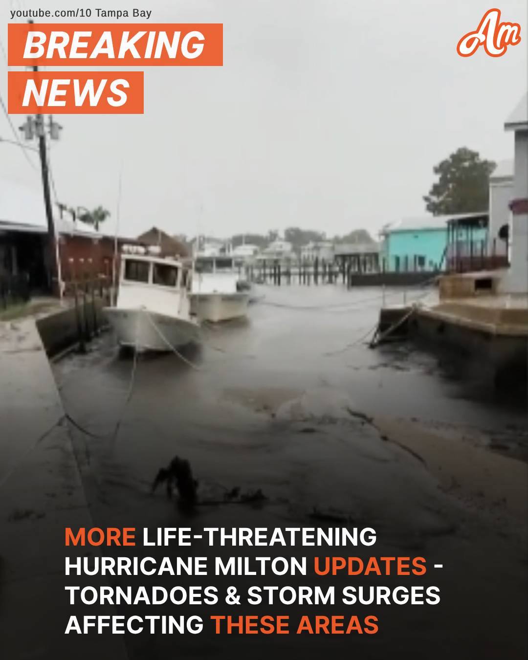
As the storm progressed, conditions continued to worsen, with reports of street flooding emerging by 4:20 p.m. (EST) in southwestern coastal communities. NWS Miami warned, “Given #Milton’s fast forward speed, the increase in water levels may be sudden. DO NOT DRIVE THROUGH SALTWATER!”
At 4:48 p.m. (EST), NWS Miami issued a critical visual update about an ongoing tornado near Wellington, Florida, urging residents in the affected area to seek shelter immediately.
Just minutes later, at 4:55 p.m. (EST), the agency released another urgent alert, warning of a tornado heading toward populated areas, specifically Loxahatchee Groves and the Acreage.
At 5 p.m. (EST) the National Hurricane Center (NHC) issued a critical advisory warning of life-threatening storm surge and hurricane-force winds expected across the west Florida Peninsula. The advisory emphasized the dangers posed by extreme winds and the potential for catastrophic storm surge as the hurricane approached the coast
At 5:13 p.m. (EST), NWS Miami warned of rough Gulf waters and a rapidly rising storm surge, advising, “PLEASE stay away from the Naples Pier and all beaches along the Gulf coast.”
By 5:15 p.m., the storm surge threat had worsened, with the NWS reporting that surge levels continued to rise rapidly at the North Naples Bay Tide Gauge. Communities across coastal Collier County were beginning to flood, prompting urgent calls for residents to seek higher ground.
At 5:24 p.m. (EST), the NWS added more information, “LARGE MULTI-VORTEX TORNADO REMAINS ON THE GROUND NOW MOVING INTO MARTIN COUNTY.”
Just three minutes later, at 5:27 p.m. (EST), they wrote, “DAMAGING LARGE TORNADO HAS NOW MOVED OUT OF PALM BEACH COUNTY.”
According to NWS Miami, by 6:00 p.m. (EST) it had issued 55 tornado warnings, contributing to a total of 98 warnings across the Tampa Bay, Melbourne, and Miami areas. At least nine confirmed tornadoes had struck the Miami region by that time, underscoring the unprecedented severity of Hurricane Milton’s impact on South Florida.
Their following post around the same time further confirmed the ongoing storm surge, warning, “🚨 Storm Surge Ongoing 🚨 Water levels continue to rapidly increase across southwestern Florida as #Milton’s surge moves in.”
Residents are urged to continue monitoring the latest updates from trusted sources and seek safety immediately. Remain informed, exercise caution, and follow necessary precautions to protect yourself and your family during this extreme weather event.